Not long after he started playing outdoors, Jiyou pulled me to Xinjiang. At that time, the first reaction was that Xinjiang was full of Gobi Desert. What fun was it was until we read the post to understand that Xinjiang had more than just the Gobi Desert and vast grasslands. Majestic snow-capped mountains, peaceful lakes and dense forests, and then did not hesitate to go.
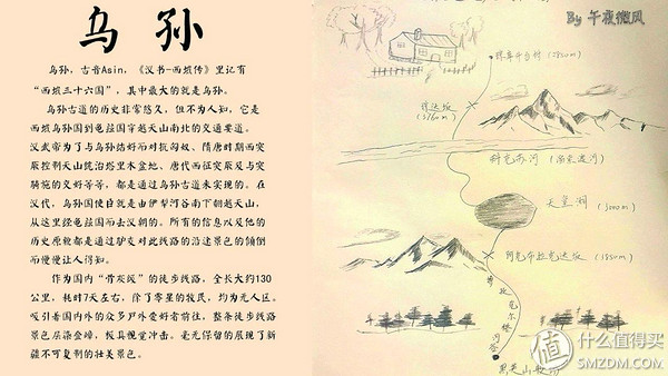
Less than Xinjiang does not know that China is big. It occupies 1/6 of the area of ​​China's territory. It is a different day and ten different scenes. It is not an exaggeration to eat watermelon around the stove at noon. In the past few years after returning, I went through many places such as Sichuan and Nepal, but still liked Xinjiang. I also knew the Wusun ancient road and my heart yearned for it. Afterwards, the equipment purchase was based on its needs. After all, it was also part of the Chinese abuse line. One of the top ten, high-performance, need to take into account the harsh climate, heavy snow, light weight, need to carry at least 6 days of food, -15 degrees to 30 degrees of warm clothes and sleeping bags, each gram needs to be considered, perhaps a little Exaggerated, but because I want to bring drones and photographic equipment including tripods, I have to choose carefully for the necessary equipment for hiking.
Because I like to take pictures, I always hope to go from mid-July to August. Only when the black osmanthus is green, the flowers are open, but it can only last for two months. It is also because of the temperature, which belongs to snow melting. During the peak period, the number of river crossings will increase indefinitely. The river is extremely cold and the water flow is rushing. Therefore, many small partners would like to go from September to October. At this time, the snow melting season is nearly over. The weather starts to be cold and the water volume will be greatly reduced. Some people may say that you can go on your own, but outdoor activities such as this kind of abuse line, a good team, and a group of reliable teammates are the basis for success. As the saying goes, there are no brothers and no climbing. It was not until May of this year that there were some small partners planning to go to Wusun in early August. The opportunity for many years to come to mind finally came. There are some roads where you don’t go now and you may not have a chance afterwards. After setting, it is all kinds of buying, buying, buying, various equipment and food.
Fixing makeup on foot

At the top is the DJI Elf 2 antiquity model, personally feel that the current Elves 3 Standard Edition is still very good, cheap, quality of the film is fully enough.
Mountaineering bag: granite halo tracking 70L personal feeling more than 25kg bear or uncomfortable, 22kg normal, may itself be designed for lightweight travel.
Walkie-talkie: Yaesu FT-277, U paragraph, bought at the time of the original research, the original battery compartment can hold 6 AA batteries, with Energizer L91 disposable lithium battery, no matter the weight, the performance of the battery at low temperature, in the long line Very good advantage.
GOPRO hero4 silver version is very suitable for daily use, its own display screen greatly facilitates the viewfinder and operation, greatly improving the quality of the film.
Trekking poles, BD's entry-level, external locks facilitate real-time adjustments and are purchased at Thamel in Nepal at a price lower than the first rich price.
Kettle: The original US Army 1 scaled kettle, 0.98 litre, with titanium alloy pot. Hot water will not leak, and cold nights can be used as hot water bags in sleeping bags. The disadvantage is that it is not transparent and can not be cleaned very well. There is a transparent version of the Black Hawk that can be bought.
ESS protective glasses, looks like this has been discontinued, less than 200 oceans. Why is the protective glasses not called sunglasses? A large area can be used for lateral winds. This is very useful for high altitude mountaineering and cycling. The lenses can resist the impact of 6mm steel balls at a high speed without breaking, even if they break, they will not cause debris. Secondary damage to the eyes.
The train was selected for the trip. Tickets were less than 700 pieces. Starting from Shanghai, 40 hours, all the way from east to west across China, returning to the plane, more than 5,000 kilometers, flying more than 4 hours, deliberately avoiding other airlines during the Spring and Autumn Period. The location can be a little bit spacious, 2400 pieces, late more than 20 minutes, it is rare.
The official itinerary begins in Urumqi. It takes 10 hours to travel to Yining on the evening of the day. After getting off the bus, it takes approximately 5 hours from the Turks to the start of the trekking Qiongkushi.
Tips: Xinjiang time is 2 hours later than Beijing time, 7 o'clock in Beijing time is 5 o'clock in Xinjiang time, Xinjiang is about 9:30 o'clock in Beijing time, about 22:00 o'clock in Beijing time. And we go out at 10 o'clock in the morning and go to at least 20:30.
Well, let's look at a video first to fully understand the whole process.
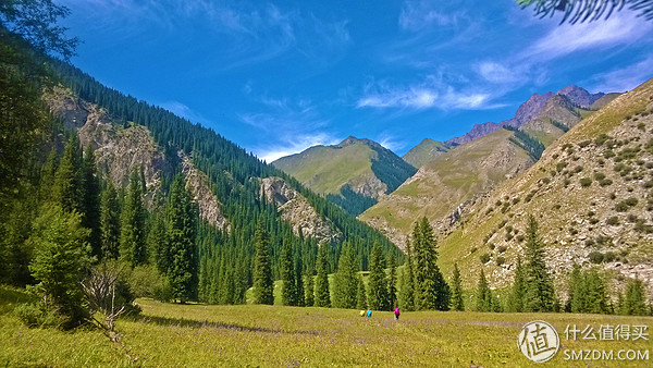
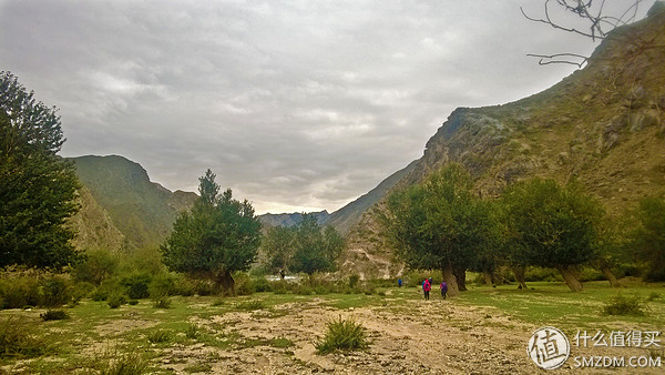
D1 Jongkustai 1900m - Log Cabin Edge Camp 2100m
The journey is easy, the grass is gentle, and the walk is 3 hours and the height is 200m.
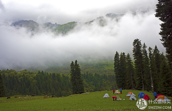
D2 Log Cabin Forest Edge Camp 2100m--Bag Pier Dunda 3600m--Bundle Pier Camp 3400m
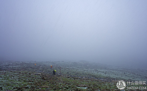
This began to be abused. Not only the length of the line, but also the height of the climb, the road conditions started to deteriorate, and when it was reached, there were strong winds, hail, heavy snow, and moderate rain. Visibility was extremely low. Everyone has experienced a lost experience.
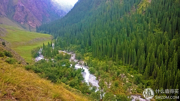
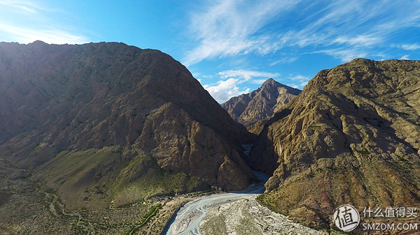
D3 wraps the ditch under the pier 3400m - zipline - Koksu River camp 2000m
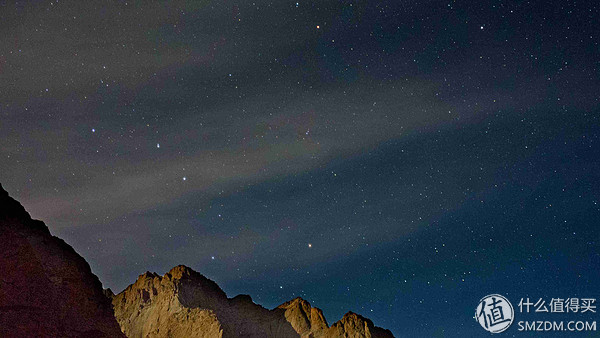
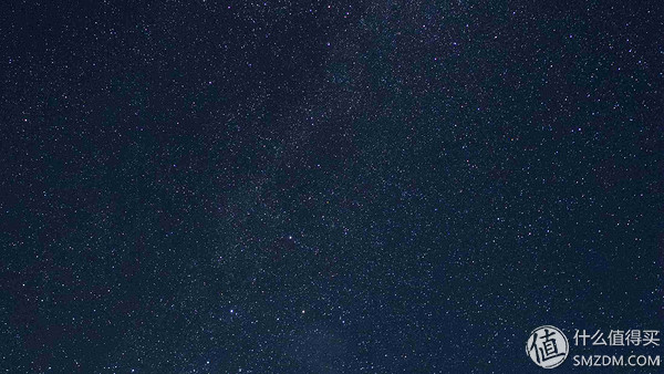
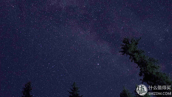
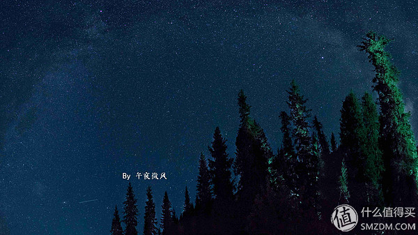
I started downhill all the way, grass slopes, all the way to the green grass, flowers in full bloom, floral bursts, but because it is heavy (boys have more than 25kg load), but also continuous long downhill, everyone's foot blisters are from this day At the beginning, until the end, our greatest enemy is the blisters on our feet. On the road, because the landslides cannot follow the original route, they will be rerouted to other routes, and they will take 3 hours to go. The sleek route to the camp is 22 points. Fortunately, the goddess of luck sees us suffering too much today. Let us on this Tanabata evening. Seeing the Milky Way, a whole Milky Way, from the side of the sky over our heads to the other side of the sky.

D4 Koksusu River Camp 2000m - Koksusu River Camp 2000m
One of the characteristics of the abuse line is shown here. It is impossible to follow the GPS trajectory of the predecessors. The message in no man's land is blocked. The signal of the mobile phone is not to be thought of. The maritime satellite phone is also in the canyon and there is no signal. The collapse caused by geological disasters blocked our planned route. Therefore, in order to bypass the landslides, the climb and descent are very large. We also need the Pioneers to explore the road, and we encounter moderate rain, which takes a lot of physical strength and time, but The straight line distance only progressed a few hundred meters.
D5 Koksusu River Camp 2000m - First Grassland Camp 2200m
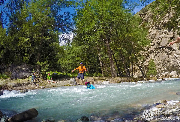
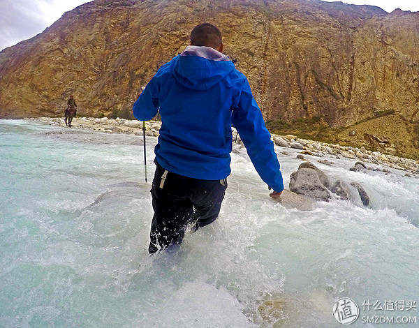
Today we are going to cross the river. Everyone is psychologically prepared, but the reality is still cruel. The icy and rushing currents still make us all lose our smiles. Two sisters who had walked with each other had not stood firm enough to be washed down. After being dragged ashore, they immediately changed their clothes and drank hot drinks. Fortunately, the sunshine was good at this time. The whole man was relieved from the loss of temperature and fright.
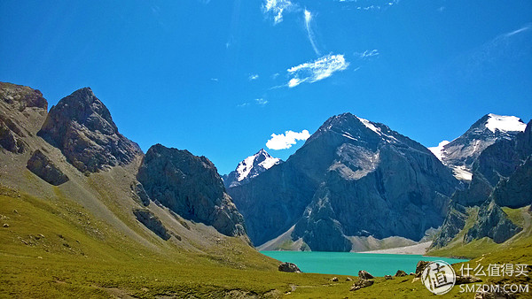
D6 First Grassland Camp 2200m - Paradise Lake Tail 3100m
After hardships finally came to the legendary Paradise Lake, there is quite a feeling of dare to go for the journey in the West, usher in the sunrise sent away sunset, a period of ups and downs, over the mountains and water, all the way to the world.

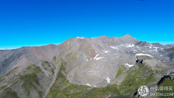
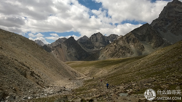
D7 Heaven Lake 3100m - Akbulakda 3800m - Akblakda 2500m
It was still very difficult to cross this trip with the highest Akblak dad. With the lessons of the previous wrap piers and the on-the-spot adaptation of the past few days, and the continuous consumption of food, the weight of the backpack has been reduced a lot. When we set off, it was discovered that Daban had been overcast when it crossed the valley and fell to the valley. When he was released, his teammates started the KTV mode and sang the theme songs of the four classics except the Dream of Red Mansions. Generally speaking, it is forbidden to do such things at high altitudes. Like the Dengshan, it must be at dawn or earlier, when the temperature is cold, but the weather is relatively stable. All the way down to the last camp of this trip, which is already in southern Xinjiang, and the northern landscape before it began to be completely different, low shrubs, bare mountains, more and more desolation.
D8 Akblakda Camp 2500m - 1900m near Black Mountain
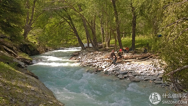
More than 7 o'clock departed, today's content is down the river, because there will be obstacles along the river, you need to cut to the other side of the river, after a few rivers have been unclear, 30 or 40 times at least, The advantage is that this extremely cold river makes the blisters on our feet lose pain and pain, and it takes a little pain to know that the previous few days were walking on the forefoot because my heels had a huge blistering 3.5cm in diameter. . At the time of the successful export and convergence of our vehicles, Wusun took a hike to the end of the journey and traveled from Heiying County to Kuqa to Urumqi.
As one of the country's top hiking routes, my writing is not enough to reflect its beauty and our pain and happiness, but I want to write something and give memories of this journey. The road I walked through will slowly blur. The scenery will be forgotten, but the former friendship of teammates will never forget.
If there is a need, I will open another article to use this example of Wusun to introduce some equipment, diet, and my own experience. Perhaps some classmates will use it in future outdoor activities and travel.
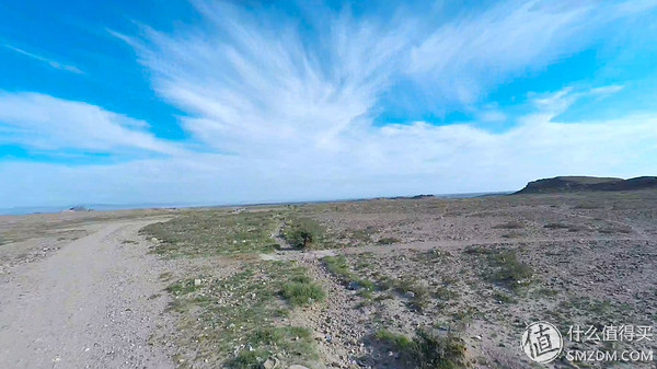
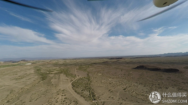
Here is the first time to participate in outdoor activities with drones
Thank you for watching. If you have any deficiencies or mistakes, please correct me.