〖UAV monitoring and positioning series of articles〗
In the third phase of serialization, a course of treatment, Keysight has developed a good medicine for the “diseases†that have been plaguing airport and other key facilities. In this issue, Keysight’s siege lions will use the stunts of “thousands of eyes, smooth ears†to listen to the wind and demonstrate the ability to “see the drone through the dark cloudsâ€.
UAV Monitoring and Positioning Solution Phase III
seeing is believing
The field test was carried out in the vicinity of Beijing Guanting Reservoir in late May 2017. It consists of three small outdoor monitoring stations (using four or more monitoring stations to achieve better monitoring results and positioning accuracy) and N6820ES Signal Surveyor 4D software and N6854A location server software. The typical configuration for each monitoring site is as follows:
N6850A broadband omnidirectional antenna (users can also bring their own antennas);
N6841A RF sensor, installed N6854A Geolocation Server software, operating frequency 20 MHz to 6 GHz, meets IP67 protection standards, equipped with GPS antenna, AC power supply, mounting bracket, etc.
8 m retractable mast, 4 m N-type RF cable, low noise amplifier, power supply, USB battery pack and other accessories.
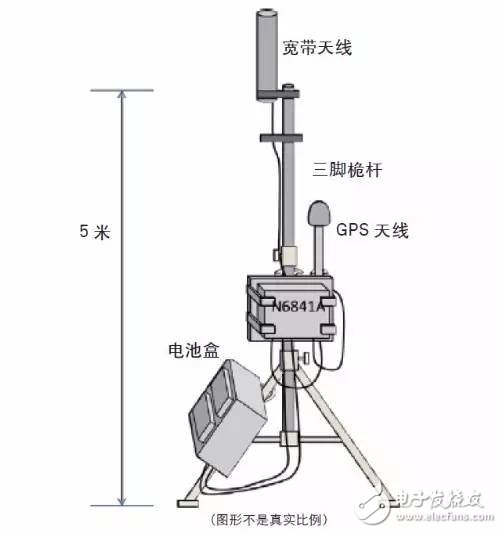
Figure 1: Typical installation configuration for the monitoring site
The specific geographic locations of the three monitoring sites are shown in the figure below.
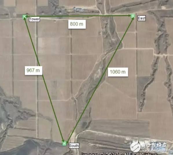
Figure 2: Actual geographic location of each monitoring site deployment
In the actual measurement, the coverage of each site was first evaluated. Take the “Tower Sensor†deployed in the upper left corner of the above figure as an example. The coverage range simulated by the SPOT tool is about 680 meters. By actually positioning a certain brand of UAV controller (operating frequency band 2.4~ 2.48 GHz, transmitting power 20 dBm), it can reach the range of 700 meters, as shown below. From Place 1 (about 313 meters from the Tower Sensor) to Place 3 (about 636 meters from the Tower Sensor), the source can be successfully located. In actual use, the user can extend the coverage to 1~2Km by selecting an antenna with a certain gain and reducing the loss of the cable.
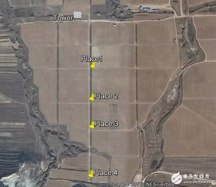
Figure 3: Field measurements of monitoring site coverage
In this test, the N6841A RF sensor adopts a 7MHz analysis bandwidth and 6000 sampling points configuration to achieve a positioning result update rate of about 2 seconds, and the accuracy of the positioning result (positioning error of not more than 20 meters) and reliability are also obtained. Guaranteed.
Next, during the actual flight of the drone, the positioning of the UAV and its controller was successfully realized, and the error range was no more than 50 meters (see the figure below). The N6820 ES software is used to perform signal recognition classification and positioning result output. The N6854A software locates the video backhaul signal transmitted by the drone, and combines the industry's unique signal lookback (LookBack GEO) and time synchronization technology. The precise positioning of the frequency hopping signal transmitted by the controller is realized.
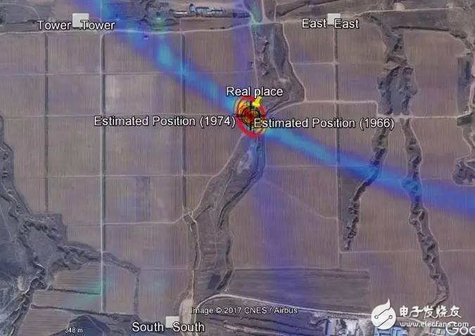
Figure 4: Positioning results for the drone
In addition, users can also choose 89601B software to implement comprehensive demodulation and vector signal analysis. In order to collect, analyze and manage a large amount of spectrum data in key areas, help users to restore the “pure and true†spectrum environment.
Finally, the following figure shows the process of locating and tracking the flight path of the drone. Looking at a little "circle" , it is very simple, red is the trajectory that is located, and the purple arrow represents the direction of the path of the drone. It can be observed that the system can accurately locate and track the flight process of the drone, even on the edge of the monitoring range, and can accurately reflect the results on the map.
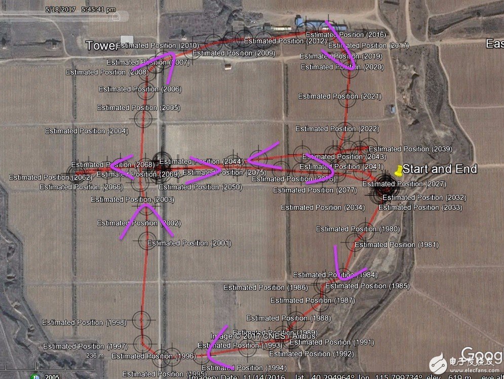
Figure 5: Location and tracking process of the UAV flight path
Operation and positioning results of the actual field test
to sum up
Through three consecutive discussions, we will provide new ideas for drone control in airports, air traffic control departments and radio regulatory agencies, standardize the use of drones, and promote the healthy development of the industry.
More stable performance
Disposable ecig have a completely enclosed design, reducing the need for charging and replacing cartridges. The no-charge design also reduces the occurrence of faults. It is understood that with rechargeable e-cigarettes, each cartridge needs to be charged at least once and the battery efficiency is extremely low, while the design of disposable ecig can solve this problem very well.Disposable ecig are very easy to carry on daily trips, no need for any operation in the use of airflow induction, direct suction can be out of smoke, meaning that you just need to suck directly on the hand can be the main feature of the small cigarette is practical portability is the main, its appearance is very small, no longer like the previous big smoke box mechanical rod nowhere to put.
The market outlook for disposable ecig
There has been a controversial topic regarding the use of disposable ecig. According to scientific studies, the long-term use of e-cigarettes can cause harm to the human body, no less than tobacco. Therefore, it is important not to overuse either type of e-cigarette - after all, smoking is bad for your health. Specifically, the PMTA requires that any new tobacco product be approved by the FDA for legal promotion and that the FDA consider all aspects of the product to be beneficial to public health. Our products can always be sold under the supervision of the PMTA at cost and are prohibited for sale to minors. We have strict guarantees regarding the quality of our products.
Disposable E-Cig,Disposable Vape Pen Oem,Best Disposable Vapes,One-Time Use Vape
Shenzhen MASON VAP Technology Co., Ltd. , https://www.disposablevapepenfactory.com